·
 ·
12 min read
·
12 min read
RIDING ISRAEL: The Western Galilee After the War

The war with Hezbollah in the North of the country is hopefully over, and I had the chance to go out to visit the most beautiful part of the country (in my opinion) and see what the war had done to it.
I went there with a tour of the BMW Motorcycle Club Israel, and as a side effect I managed to discover an itinerary that can either be an alternative to the itinerary I published in my first article in the Riding Israel series, or be merged into that itinerary to create a great ride for one full day.
Differently from the original article, this time I managed to get live footage of the riding in the different parts of the itinerary, and I will include the riding footage in this article. Note that these are all raw videos which I filmed with my Insta360 X4 and reframed to prepare them for my final video of the trips, which appears at the end of this article.
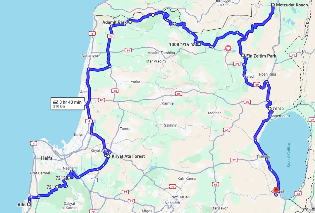
Above is the map of the itinerary. Differently from the previously published itinerary, which began in Tel Aviv, this time it begins in the Northern city of Atlit, for the simple reason that this was the meeting point set by the BMW Motorcycle Club Israel. One might begin the tour from Tel Aviv or any other point and do the same itinerary after that.
Beit Oren Road
Our first segment of the trip is going up the Carmel Mountains through the Carmel Forest, and the best way to do that is the Beit Oren Road, or road 721.
The road to Beit Oren, or Beit Oren Road, is one of the preferred roads by motorcyclists that live in the center/North of Israel.
It is an old twisty road that goes up the Carmel Mountains from its Western side, passes through the Carmel Forrest, Kibbutz Beit Oren and the monument to the dead at the Carmel Forest fire of 2010. The monument keeps the remembrance of the 44 dead in the Carmel Forest fire of 2010, which lasted 4 days - 3 senior police officers, including the Chief of Haifa's police, 36 Israel Prison Service new recruits, and 3 firefighters, among them a 16-year-old volunteer.
It ends at the top of the mountain, at the junction with the road between Haifa and Isfiya/Daliyat El-Carmel.
Once a very old and badly maintained road, it has been renovated and is currently a pleasure to ride. The asphalt is new, and the curves make it a thrilling ride. The views around the road are beautiful, and the forest is completely recovered.
In the following video you can get a good idea on how it feels to ride there.
Nesher Road
Following the Beit Oren Road, we went down from the Carmel Mountains through their other side, the Eastern side – the Nesher Road.
The Nesher Road begins at the highest point of the city of Haifa and goes downhill at the margin of the city of Nesher, a satellite city to Haifa. It ends near the Checkpost Junction, which gives the access to the Northern Haifa neighborhoods.
Surprisingly (for me), it was not worse than the Beit Oren road. It offered beautiful curves and a stunning view from the top of the mountain to the Haifa Bay and the Northern neighbourhoods of Haifa.
Check the view and the riding on the video below:
Kiriyat Ata Forest
The Kiriyat Ata Forest is a beautiful park near the Kiriyat Ata neighborhood of Haifa. It's a beautiful forested area that offers a variety of outdoor activities, including hiking, mountain biking, and bird watching.
Usually, due to its proximity to Haifa, this park is very busy, but it is large and has a large number of picnic areas with tables and parking lots.
It is a perfect place for a breakfast or brunch picnic to rest a little from the motorcycle ride. Additionally, riding a motorcycle inside the main road of the forest is a beautiful and calming activity. You can get an idea of the beautiful riding in the video that follows.
A bThe ascent to the Adamit Park and the Arch Cave
We continued riding Northwards, and reached the communities near the border with Lebanon, where we took the New Northern Road, Road 899, from the town of Shlomi, to the East.
After some Kilometers on road 899, we took the Ascent to Adamit park, which is the beginning of Road 8993, the Historical Northern Road.
The Historical Northern Road is the old road that separated the territories of Lebanon and Israel, passing through all the Israeli border communities. It was already there for many years when the British decided to pave the new Northern Road (Road 899) in 1937 in order to help them suppress the Arab Revolt. Road 8993 begins at the Junction with Road 899 near Adamit and ends at another junction with Road 899 near Matat. At this segment rising from Road 899 to Adamit, the road is a serpentine of hairpins going from sea level to the 400m height of the park. Beautiful scenery can be viewed from this road, from different heights, making it a breathtaking ride. The road offers at some points wide shoulders where you can park the bikes, watch the scenery and take pictures.
Here is a short video of the way up the road.
Adamit Park and the Arch Cave
I have a chapter about the Adamit Park and the Arch Cave in the previous article - I called it Keshet Cave there, since Keshet is the Hebrew word for Arch. This it the point where you can begin merging this itinerary with the itinerary I have mentioned in my previous article.
Adamit Park is located in the Western Galilee, near the border with Lebanon.
It's part of the Rosh Hanikra Ridge and offers breathtaking views of the surrounding landscape, including Haifa Bay and the Western Galilee.
The park is situated at an elevation of about 400 meters above sea level, providing pleasant breezes and stunning vistas.
The park features several marked trails, including the Terrace Trail, which leads to the Arch Cave (Me'arat HaKeshet), a fascinating cave, which you will soon see, with a narrow strip of rocky land suspended over a void like a hanging bridge.
I have recorded the walk from the parking lot of the park, where you can park your bikes, to the Arch cave, a walking trail of 5 minutes downhill that shows a beautiful scenery of the Western shore of Israel and the Mediterranean Sea.
The Historical Northern Road (Road 8993)
After Adamit Park, We continue our way through the Historical Northern Road.
Road 8993 or the Historical Northern Road is a regional road in northern Israel, located near the Israel-Lebanon border. It runs eastward and is known for its scenic views and proximity to the border.
The road is part of the network of roads in the Upper Galilee region and offers access to several local communities and attractions.
This road has been described in my blog article about the Western Galilee at my website.
It’s proximity to the border with Lebanon is extreme, as you will see marked in this video.
At some points you travel just by the border fence.
During the war, this road (and also road 899, the Northern Road) were completely closed to the general public, and all the communities around the road were evacuated. Road 8993 and Road 899 have been reopened in January 2025 with the end of the war, and while Road 899 is back to its previous state, Road 8993 still shows the effects of the rocket shelling by Hezbollah and the traffic of tanks and combat cars.
At some parts it even gave us the feeling of travelling off-road.
Here are two videos of different parts of the road:
Mount Adir
Mount Adir is one of the highest mountains in the Galilee region of northern Israel, rising to 1,008 meters (3,307 feet) above sea level. It's located between Matat and Kibbutz Sasa and offers stunning views of the Galilee and southern Lebanon. The access is directly from Road 899.
It has an observation deck from which we can get a very good image of the proximity between the communities in Israel around road 8993 and the villages in Lebanon that were over the years transformed in Hezbollah attack bases.
The video below was recorded on Mount Adir, and gives a perfect idea of what is seen from there. We had a guide from the army there who gave us details about what parts of what we see are Israel and what parts are Lebanon.
Koach Fortress - The Fortress of the 28
Following Road 899, we arrive at the end to the Koach Fortress, or Metzudat Koach in Hebrew. Mezudat Koach is also known as Fort of the 28. It is at the very limit between the regions of the Western Galilee and the Upper Galilee.
Previously known as the Nebi Yusha Police station, it was originally built by the British Mandate administration during the 1936-39 Arab revolt.
Touring Israel these days, you will find many places which have a number in their names. Many times these names refer to battles in the Independence war when Israel was attacked by the armies of neighbouring Arab countries in all of its borders, and had to defend themselves or attack back in order to get an advantageous position. This is the case here, and the 28 are the twenty-eight soldiers that died trying to conquer back the Nebi Yusha Police Station, after it was conquered byt the Arabs.
The fort was a strategic observation point overlooking the Hula Valley and the main road to Upper Galilee. It was attacked multiple times by Jewish forces during the 1948 war, resulting in the deaths of 28 Israeli soldiers, the reason for its name.
The fort was eventually captured by the Yiftach Brigade on May 16-17, 1948.
On the grounds of the fortress, there is a memorial monument and a museum that was founded in 2014. The memorial commemorates and names the 28 soldiers who fell in the battle for the fort.
Here is a little of the museum.
Transposing the whole history to current days, it is incredible to think that Israel is still going through the same Arab attacks, and the only difference is the fact that if once the attacks were launched by the neighboring Arab states against a state in the phase of its creation, nowadays they are launched by terror organizations that just took over these states. History goes round, and the fact that they have never accepted Israel's existence and recused to sign a peace treaty with it, caused fanatism to grow inside these countries, and in many cases like Syria, caused the government to fall, or like in Lebanon, caused the country to become a hostage of a terror organization. Talk to any non-Shia Lebanese and they will confirm what I say here.
Road 886
We began travelling South via Road 886, which begins in the Misgav Am juntction with Road 899, passes through Ramot Naftali, Dalton, Alma and other communities, and ends at the junction with Road 89 at Ein Zeitim.
The road is a very nice ride, full of fast, medium and slow curves, with its asphalt in acceptable condition.
At the end of the road we can choose between taking the faster road 89 to the Elifelet Junction, or taking the slower 8900 Road through the Byria Forest to Rosh Pina, and this will probably depend on which direction you will continue from there.
We took road 89 since we are travelling now South, on our way back to the center of the country.
Here is a bit of the riding there:
Road 90 - Korazim Road
In my previous article for the Western Galilee in the RIDING ISRAEL series, I suggest that you consider sleeping in Safed (Tzefat) for continuing to the Upper Galilee and the Golan, before entering the Lower Galilee area. This time we are going to the Lower Galilee, as part of our way South back home.
From Road 89, At Elifelet Junction we take a right to Road 90 in its Southwards direction.
After some Kilometers, a little after Ami’ad, we will turn left in the direction of Tiberias, continuing on road 90, which at this segment is called the Korazim Road.
Korazim Road is a route that runs through the Korazim Plateau in northern Israel. It connects various historical and archaeological sites, including the ancient village of Chorazin (Korazim), which is mentioned in the Christian Gospels.
The road offers scenic views of the surrounding landscape, including a stunning overview of the Sea of Galilee, locally known as the Kinneret Lake, and has a MUST-STOP point to observe the view at the Mount of Beatitudes.
On our way we will go down from 240 meters height at the area of Ami’ad to -240 meters (yes, 240 meters under sea level) at the Sea of Galilee.
The Sea of Galilee was once the only water source in the region, and its water was explored by Israel but provided also to Jordan. Nowadays, with the rising of the desalinization technologies in the area, the lake is responsible for only 30% of the drinking water produced in Israel.
The area is also an important tourism area in Israel. The area is already considered as part of the Lower Galilee county, which has its center on the city of Tiberias. There you can find hotels and attractions, and I suggest you refer to the Lower Galilee previous article that I wrote in my series Riding Israel.
Here I finish this article. As I said, if you take a careful study of my previous article on the Western Galilee, you will easily find the points of merging the two itineraries. From here, you have two options: if you are continuing to the Upper Galilee and the Golan Heights as I proposed in my series, you can sleep on Tiberias or Safed. If you are going to the South, there are many exits to the South in this region, some of them very beautiful. Look at my Lower Galilee article for a suggestion.
And to end, here is the fully edited video of the day, with all the places marked - 28 minutes.
0 Comments